Map of Illegal Sects in Cernăuți (Chernivtsi) county Romania 1941
Item
Title
Map of Illegal Sects in Cernăuți (Chernivtsi) county Romania 1941
Harta sectelor ilegale din județul Cernăuți, România 1941
Description
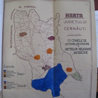
This map showing the “Zones of activity and distribution of illegal sects in Cernăuți county”, which is preserved in a 1941 folder of the Romanian General Inspectorate of the Genndarmerie, actually dates from 1st July 1942 (the date appears in the bottom left corner of the map in very small writing). It was created following the reincorporation of the province of Bucovina, of which Cernăuți county was a part, into Greater Romania following the Axis invasion of the Soviet Union in June 1941. The map shows the distribution of five banned religious communities, Nazarenes, Reformed Adventists, Lipovans (Old Believers), Pentecostals and Stilists (Old Calendarists).
Under Marshall Antonescu, Romania’s wartime dictator, Romania pursued an extremely harsh anti-sectarian policy that effectively banned most religious associations and sects. The Antonescu regime, considered religious sects as especially dangerous as they undermined the unity of the ethnic Romanian population, which according to state ideology should be exclusively Orthodox. Some groups such as the Nazarenes, Adventists, Jehovah’s Witnesses and Inochentists also refused military service, which was considered a threat to the Romanian war effort. The mapping of religious communities was a necessary step in order to facilitate the systematic appropriation by the state of their property, and the arrest and imprisonment of leaders.
This map comes from Archivele Naționale Istorice Centrale ANIC – fond. Inspectoratul General al Jandarmeriei (Romania), dosar. 160/1941
Această hartă care arată „Zonele de activitate și distribuție a sectelor ilegale în județul Cernăuți”, care este păstrată într-un dosar din anul 1941 al Inspectoratului General al Jandarmeriei din România, datează de fapt din 1 iulie 1942 (data apare în colțul din stânga jos al hărții în scris foarte mic). A fost creată ca urmare a reîncorporării provinciei Bucovina, din care făcea parte județul Cernăuți, în România Mare, în urma invaziei Axei în Uniunea Sovietică din iunie 1941. Harta arată distribuirea a cinci comunități religioase interzise, nazareeni, adventiști reformați, Lipoveni (credincioși pe rit vechi), penticostali și stiliști (pe stil vechi).
Sub conducerea mareșalului Antonescu, dictatorul României în timpul războiului, România a urmat o politică antisectară extrem de dură, care a interzis efectiv majoritatea asociațiilor și sectelor religioase. Regimul Antonescu, a considerat sectele religioase ca fiind deosebit de periculoase, deoarece subminează unitatea populației etnice românești, care, potrivit ideologiei statului, ar trebui să fie exclusiv ortodoxă. Unele grupuri, cum ar fi nazareenii, adventiștii, martorii lui Iehova și inochentiștii au refuzat, de asemenea, serviciul militar, care a fost considerat o amenințare la efortul de război românesc. Cartografierea comunităților religioase a fost un pas necesar pentru a facilita însușirea sistematică de către stat a bunurilor lor, precum și arestarea și detenția liderilor.
Această hartă provine de la Archivele Naționale Istorice Centrale ANIC - fond Inspectoratul General al Jandarmeriei (România), dosar 160/1941.
Subject
Religion -- History -- 20th century
surveillance
Creator
James A. Kapaló
Source
Archivele Naționale Istorice Centrale
ANIC – fond. Inspectoratul General al Jandarmeriei (Romania), dosar. 160/1941
ANIC – fond. Inspectoratul General al Jandarmeriei (Romania), dosar. 160/1941
Publisher
This project has received funding from the European Research Council (ERC) under the European Union’s Horizon 2020 research and innovation programme No . 677355
Date
1941
Rights
Copyright for these images belongs to Arhivele Nationale - ANIC
Format
image/jpeg
Language
RO
Type
image
Identifier
Archivele Naționale Istorice Centrale
ANIC – fond. Inspectoratul General al Jandarmeriei (Romania), dosar. 160/1941
ANIC – fond. Inspectoratul General al Jandarmeriei (Romania), dosar. 160/1941
Coverage
Romania
Ukraine
20th century
Bibliographic Citation
James A. Kapaló, "Map of Illegal Sects in Cernăuți (Chernivtsi) county Romania 1941",
Date Created
2020